What we are all about

Living on the Edge is the field study of earthquakes, volcanoes, and other hazards where tectonic plates collide. Field studies focus on understanding the science behind natural hazards that lead to catastrophic events and subsequent loss of life. Fieldwork is aimed at recognizing hazards and understanding the processes behind the hazards. The blog chronicles the participants and their experiences in Alaska Summer 2008

Wednesday, July 16, 2008

Web Albums!

Ok now that my computer is back in running condition I can upload a selection of photos to web albums in Picasa. All you have to do is click on the photo - it is the link.

Around Denali -
LOTE 2008 Denali


Valdez - Denali Fault System/Pipeline -
LOTE Valdez - McCarthy - Donnelly Creek/TAPS Pipeline - Tangle Lakes - Healy


Homer - Cordova -
LOTE 2008 - Homer - Seward - Exit Glacier - Cordorva - Childs Glacier - Alaganik Slough - Hartney B


Kodiak Island -
LOTE 2008 Kodiak Island


Flight into Anchorage -
Flight into ANC

A Favourite Moment for Many

Childs Glacier calving into the Copper River!

video

Wednesday, July 9, 2008

Final Thoughts from the Students **updated**

****My computer is back and I have added Shannon's last Blog below!!****

Today has been a long day - starting with the black bear that wandered through camp at 2am this morning and caused quite stir at the not so tidy campsite across the road. The bear went past Joe and Jon's tent waking them up after it past between my tent and Garver's tent. Garver woke me up, I was certain it was just the very healthy, large arctic ground squirrel and that there was nothing to be worried about. Garver spoke with Joe and Jon by the time the bear moved on. Lenny and Sam slept through the whole thing, as did Amanda and Kaitlin, Shannon did wake up and got a recap from the guys. So yes quite the start to the last day! A lot of fuss for a squirrel if you ask me.
While we were cleaning up for our flights home the students worked on some final thoughts. Unfortunately Shannon's final thoughts might have been the final thoughts EVER written on my computer - it won't turn on, so her final words are a secret for now. But we do have everyone else's final words and a few more pictures to share. In the next couple of days there will be some movies and links to other photos posted. This was an awesome trip and Garver and I are very impressed with by what the students have accomplished - well done - it doesn't get better than this!!

Joe: To sum up the past few weeks I have to use the words awesome, sweet, schist and fish-on. The professors were able to captivate everyone on the trip and maintain the most extreme and fascinating outdoor classroom possible. We saw wildlife on every turn ranging from mouse to moose and bees to bears. There is something mesmerizing about standing at the foot of a calving glacier and feeling it’s thunderous collapse. This trip was a great learning opportunity and I would do it over again in a heartbeat.

Jon-Hot-Diggitty-Dog, what a trip, what a class, what a crew. These three weeks have flown by and it’s been a blast. For me it was like Christmas every morning, I couldn't wait to get up and get going. I have so many incredible memories from this trip including one little adventure last night when a bear came running through our camp at 2:30 in the morning. I can’t imagine coming to Alaska with a better group of kids, everyone was amazing.

Amanda: I can’t believe our three weeks here in Alaska are already up! After our exam last night, we shared our favorite parts of the trip, and one of everyone’s top favorite days was the Childs Glacier hike where we saw some unreal glacial calving. This trip has been an amazing start to my senior year. It has given me a lot of insight about myself and what I’d like to be doing in the future after graduation. I have met some truly remarkable people on this trip who I hope to spend a lot of time with at Union when we return. I will especially miss Kaitlin’s sleep talk that I usually wake up to every night. One of my favorite lines was, “My chocolate? I’m not in the fish.” I hope to return to Alaska in the near future and spend some time exploring this place on my own.

Kaitlin: As we pack up to leave, it seems hard to believe that our three weeks here are over. Our last campfire was full of good stories, videos and lots of laughs, a true indicator of a great trip! I have learned so much and am thankful for the great friends I have made here- this is definitely a great start to my geology career at Union. Although I will have to do without my nightly smore-making at home, I look forward to our reunion back at school!

Lenny: Today I am leaving Alaska, I’m left with bittersweet feelings as I’m excited to go home but I am going to miss Alaska. The whole trip has been exciting from the start of the trip on Kodiak to the end around Denali. We were able to witness spectacular natural events like the calving on Child’s glacier, the Grizzly walking across the Copper River Delta and the water flowing through the ice caves under Castner Glacier. Hopefully I will be back here again soon.

Sam: This was an eventful three weeks. The group learned a ton about Alaska, and our largest state. My favorite two stops were the Kennecott mine and the Gunny Sack Creek. I found the diverse mineralogy very interesting at both these stops. I also really enjoyed the Childs Glacier calving. I learned many new concepts, not only about geology , but about environmental science as well. Camping was certainly a new and interesting experience for me. I will never forget this trip.

Shannon - Looking back on this trip to Alaska, I am unable to think of a better way to start off the summer. I was surrounded by eight other adventurous, outgoing individuals for the past three weeks and there was never a dull moment within the group. Although the trip was an amazing experience, there are several specific events that reign above the rest as my favourites. The hike on Childs Glacier was one of the most memorable moments because it was my first glacier encounter and the massive calving events were mind blowing. Nevertheless, the simple activities such as swimming in the Pipeline Lake, hiking on the McKinley Trail, and sleeping outside on the ferry during our return from Kodiak will remain in memory forever. The wildlife sightings were remarkable as well. All in all, I couldn’t have asked for a better trip to the Last Frontier. It was an incredible opportunity that I am extremely happy I took advantage of. Thanks to everyone for this fabulous experience!


Tuesday, July 8, 2008

We have contact!!

Hi ALL,
Thanks for your patience with us. We have been so busy and only just now are getting a chance to update you. We have been busy since we left Valdez and headed into the largest National Park - Wrangell-St Elias to see the headwaters of the Copper River and the now abandoned Kennecott Copper Mine facilities. You will be happy to know that once we got over the Chugach Mountains (just outside of Valdez) our weather finally started to treat us right! After McCarthy we had a long travel day to the north side of the Denali Fault where we camped at Donnelly Creek for 3 nights. At Tangle Lakes we ran into the rain again :( for our drive across the Denali Highway, a very rough and remote road. The last two nights we have been at Denali National Park's Riley Creek, with some great weather (with the exception of this morning's rain). Today we are heading to Independence Mine just northeast of Anchorage and then onto Eklutna Lake Campground for our Final night (the final exam and the last night of the trip). On Wednesday morning we will get ourselves repacked, showered and ready for the flights home! There might even be a chance for a final thoughts blog posting from the Anchorage Airport. But for now read what the students have been up to for the last week and a bit!

Lenny- Today was our first full day at Denali National Park. We woke up to some wet and cloudy weather, but the sun made it out half way through our hike along the Savage River. After breakfast we took a look in the visitor’s center and then headed up the park road to the Savage River. The bridge across the river is the farthest point which you can drive into the park without being on a special tour bus. We started our hike at the bridge, where the Savage River’s channel is characteristic of a braided river. After about ¼ of a mile the river abruptly changes to a straight channel. This straight channel has higher energy then the braided channel, and has been down cutting through the narrow valley which we hiked through. Throughout our whole hike through the valley we were able to see the folded rocks of the Birch Creek Schist. During the last 6 million years the area around Denali has been undergoing uplift. This uplift is a result of the curvature in the Denali strike-slip fault, As the fault curves, rocks are essentially squeezed and folded causing them to be uplifted. This uplift is responsible for the creation of the Alaska Range and the folded rocks along the Savage River. We continued hiking down the river to the knickpoint (or waterfall) which had been buried by an alluvial fan. Below this point the river is fairly straight and continues to cut down into the Birch Creek Schist. In the middle of our hike we stopped for lunch above the river and were lucky enough to spot a few Dall Sheep high on the mountain across the river. After lunch we headed back to the van and drove back down the park road towards camp, on the way we saw two caribou a few hundred feet off the road.

Sam: On July 3rd we made a variety of stops. My favourite, however, was our third stop at Gunny Sack Creek. This creek flows into the larger Delta River flowing north towards the Yukon River, and contains the Birch Creek Schist Formation. Schist is a highly metamorphosed rock rich in micas. The high mica content is analogous of a shale + sand protolith. Other than micas several other minerals were present, such as green chlorite, actinolite, some feldspar, an alteration mineral known as fuschite (chromium-rich mica)), and several quartz veins containing sulfides. Among these sulfides I was able to find my own personal samples containing what looks like chalcopyrite (a copper ore mineral), pyrites cubes, calcocite (another copper ore mineral), and possibly trace amounts of gold and silver (which have both been found in this area before).


Joe-On July 6th the group woke up and had a wonderful breakfast at the Tangle Lakes Inn just down the road from our campsite. Following the breakfast we traversed the rest of the Denali Highway. Just north of the Denali National Park entrance outside the town of Healy, we stopped at an outcrop along Suntrana Creek near the Usibelli Coal Mine. This outcrop of the well-exposed the Usibelli Group has great stratigraphy with five units of interbedded sedimentary rocks and lignite coal deposited on an unconformity above the Birch Creek Schist, a part of the Yukon-Tanana terrane. Usibelli Group deposition began in the early Miocene, probably in a swampy and low-energy depositional environment. In the contacts above and below the coal seams there are visible changes caused from the coal catching fire. The fine-grained sandstone above the coal seam was changed as if it were put in a kiln and fired, the resulting rock are called clinker. The transition in color of the section that received the most heat from the coal fire is noticeable and has a darker color, it is melt rock. Aside from the wonderful geology that drew our group to the Tangle Lakes campsite for the night of July 5th, I must mention we had phenomenal fishing. I had terrific results in the lake and on the river with a size fourteen Royal Coachman. Everyone who has fished on the trip has now landed at least one fish!!

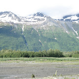
Jon- Last week we made an important stop in Valdez, not only to check out the geology but also to tend to some laundry and take a warm shower! Old Valdez was built on a delta, meaning it rested atop gravel and sand. The shaking from the 1964 earthquake caused the sediments to de-water, a process called liquefaction, and as a result the front end of the delta failed. Much of the delta slid into the water including the port facilities. This along with other slumps displaced a large volume of water and generated a local tsunami. As if this wasn’t enough the liquefaction and shaking also caused several tanks at the Union Oil Company to rupture sparking a fire that spread across the waterfront. Old Valdez was devastated and since then Valdez has been moved to more stable land on the side of the bay (behind an old glacial moraine). Since this stop obviously a lot has happened. Some highlights for me include: five amazing hikes, one taking us inside a glacial cave, a breakfast buffet at Tangle Lakes, landing a grayling with Garver’s fly rod, some beaver pond swimming, lots of hangman, and of course jamming to the Dixie Chick’s.


Kaitlin - In McCarthy in the Wrangell Mountains we started off our day with an eventful shuttle ride to Kennecot. Before we got in the dated Chevy van, we were given sharpies to sign our names and hometowns on the outside of the van and soon piled in for a bumpy ride to the small mining town. The town of Kennecot was specifically built to suit the needs of the mining business. Many of the buildings were the original structures from the early 1900’s, and now used for local businesses, apartments and even a visitor center. In 1900 two men discovered this copper deposit and identified the ore at the limestone-greenstone contact in these Triassic rocks. By ensuing wealthy East Coast families, these men were able to form the Kennecot Copper Corporation, which extracted a total of $200 million by the time of the mine’s closure. The corporation also controlled the entire transportation route, funding the 196-mile Copper River and Northwestern Railway from Kennecot to Cordova. They operated from 1911 to 1938, which is when all the copper had been depleted.
Once we arrived in Kennecot, we went on a guided tour of the small town and copper factory. We were able to go through the original mill, and were able to see all of the original equipment and tools used to extract and process the copper. After the tour we hiked to the base of Root Glacier and were able to do a bit of exploring. The weather was a challenge, changing from sunny, to rainy, to thunderstorms and back to sunny all in one afternoon! We were able to enjoy some free time in the small town and it’s neighboring town of
McCarthy for the rest of the afternoon before heading back to camp. It seems that every place we go here, the residents seem to enjoy Alaska’s beauty to the greatest extent. Whether they are living in a small mining town, a less-traveled island or fishing village, Alaska seems to bring something different to everyone. I would say that it has been a place of enjoyment and a great learning experience for us all!


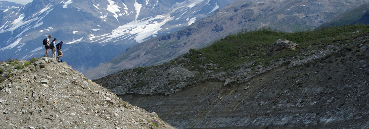
Shannon - The fourth of July was full of a plethora of fun activities. We started the day off with some tasty egg-a-muffins which was the perfect breakfast before our extensive hike on Castner Glacier inside the Central Alaska Range. Castner and the nearby Black Rapids Glacier are significant because of the hazardous surges that have occurred. These surges occur when melt water reaches the base of the glacier and act as a lubricant between the ice/rock interface, allowing the glacier to speed up its velocity to 100 times greater than normal. These events also imply that the glacier is retreating because of increased amounts of melt water supply. A glacial surge occurred on the Black Rapids Glacier in 1936. During this surge the face of the ice mass advanced about one mile each month between December 1936 and March 1937 towards the Delta River and Richardson Highway. Our hike on the Castner glacial moraine was pretty intense, but an awesome experience especially when we were all able to crawl inside an ice cave. Despite our lack of fireworks to celebrate the national holiday, the gang headed out for some fly-fishing to cap off the day. Oh and of course I can’t forget to mention that I spotted the first moose on the trip!!! As we were driving to our campsite on the Delta River, with everyone asleep except for myself (and Garver, who was driving), I saw this massive creature in a pond of the side of the road. It was about time that happened. With all that said, this trip has been out of this world!

Amanda - Unfortunately, we are nearing the end of our travels. Over the past few days, we have visited the Trans-Alaska Pipeline System (TAPS) on several occasions. No matter one’s opinion on the subject, or how “green” they are, one cannot see the pipeline for themselves without appreciating the manpower and intelligence it took to plan and build. It starts in Prudhoe Bay on the North Slope of Alaska, and ends after an 800-mile journey south to Valdez where it can be shipped off to refineries. The construction of the pipeline took three years, cost $8 billion dollars, and employed 21,000 people, killing 31 during accidents. This pipeline is an engineering marvel, not only because of the harsh conditions of the interior of Alaska, but also because it is built on a handful of active faults. Where it crosses the Denali Fault zone, the pipeline sits on Teflon skids, which allow the pipeline to move freely without spilling a drop of oil during an earthquake. Parts of the pipeline are aligned in a zig-zag fashion, which also allows it some leverage to move along the skids during an earthquake. The Denali Fault, intersects the pipeline, and in 2002, there was a 7.9 magnitude earthquake on the Denali Fault. Because of extensive research done by geologists on the recurrence intervals of the faults that the pipeline might intersect, the engineers were able to build a successful pipeline that moved during this massive earthquake and kept the oil contained in its 48-inch diameter pipe. We stood on the intersection of the Denali Fault and the pipeline, and saw the devastation that the earthquake did to the black spruce (Picea mariana) trees in the area. The trees were split in two, some suffered from scarring and deformation, and a few are growing with severe leans because of the violent shaking it experienced. With much debate about a natural gas pipeline being built through Canada or Alaska, it is increasingly important to understand the geology of the potential routes, so that a natural gas pipeline can prove as successful during mass earth movements as the Trans-Alaska Pipeline System. This Alaska experience has been amazing, and I will be sad to leave, but excited to come home and indulge in the everyday pleasures that I’ve missed at our
campsites!


Sunday, June 29, 2008

Seward to Cordova

Hi All,
Well we have showered, laundered and restocked today in sunny Valdez. The students spent this morning's ferry ride from Cordova to Valdez working on their field books and their most recent blog update. Despite the coolish and wettish weather on the Copper River Delta (Cordova and area) I think all can agree it was still amazing! We started in Seward, at the foot of Exit glacier after returning from Kodiak, traveled back through the eastern edge of the Kenai Peninsula to get to Whittier. From Whittier we took the 'fast ferry' Chenega to Cordova. We camped along the Copper River for the first two nights, right across from the very actively calving Child's Glacier, then moved to the toasty cabin at the McKinley Lakes trailhead for two nights.

We are off to Squirrel Creek campground just north of Valdez this evening, before we check out ancient Lake Ahtna sediments and travel into the headwaters of the Copper River - McCarthy, along the old railway bed (hope for robust tires!!!). After McCarthy we head to the north side of the Denali Fault and begin the final section of our trip in the Central Alaska Range! This is a great group and the science and scenery have been outstanding. Enjoy the student updates below, as always the comments are big favourites. Happy Canada Day and 4th of July in a few days, we will be able to update when we arrive at Riley Creek Campground in Denali National Park.
jc
~ps - when we get a little more time and a better connection I will upload whole albums for people to view!

Shannon – After finally sighting a large grizzly bear on Long Island Channel we proceeded to check out the Alaganik Slough on the Copper River. Here we observed a stratigraphic sedimentary column composed of silt and peat. This area of Alaska was uplifted by the 1964 earthquake and the Copper River cut down in the marshy area. We were able to understand that this region has been slowly subsiding ever since it was abruptly uplifted. As the mud/silt layer of the pre-existing riverbed was uplifted, it dried out and began to accumulate peat layers and organics. As the layers began to slowly subside down, new layers of mud/silt gradually accumulated on top as a new river bed forms. The Alaganik Slough is one of the only places in all of Alaska that is used to determine and understand the recurrence intervals of earthquakes. Each time an earthquake happens, approximately every 400 years, the land experiences sudden uplift followed by gradual subsidence. Aside from this fascinating day in the field, the hike to Pipeline Lake was surely a blast. Jon, Kaitlin, and I thoroughly enjoyed our penguin plunge into the freezing cold water. The hike was out of this world. It felt as if we were walking in an enchanted forest because there was moss covering everything. All in all it has been an amazing week. I am surely looking forward to the rest of the trip!

Sam - As we stood on the outskirts of the Child’s Glacier Campgrounds we watched enormous building size chunks of ice calve off the main body of ice. Here we not only discussed the glacier but also, the complicated tectonic activity that has lead to Alaska’s unique landscape. We learned about the northern trending terranes that comprise Alaska, as well as the nature of the subduction zone that underlies the large land-mass of this state. There are three main terranes that comprise the accretionary wedge that pertains to this particular subduction zone, the Chugach, the Prince Williams, and the Yukatat. The subducting Pacific Plate is plowing these three microplates north, and because the massive North American Plate stands in their way, these three sections are being squirted out of the accretionary complex in a north-western direction. The Pacific Plate has also caused a rip in the lithosphere. This complex tectonic setting has lead to an offset chain of volcanoes. For me, this was the most interesting lecture thus far.

Joe - Bare feet on the dashboard! The past few days have been filled with amazing glacier hikes, wildlife encounters and interesting geology. One of the sites we visited along the Copper River delta had a fascinating dune complex. In the humid dunes along the river, snags and other forms of vegetation protect the eolian sediments from being blown further downstream. Unlike the arid dunes of the Sahara Desert which are known for their fast movement across the desert, humid dunes are more stabilized. The head or windward sides of the dune complexes have steep inclined layers held by vegetation. The slip side of the dunes were protected and contained tiny slope failure marks along the crests of the dunes. Seeing the signs of slope failure gave the group a strong indication that a snowdrift would be buried under the sand. We dug down several feet and found a thick snowdrift that proved our hypothesis. As we were making our way off the dune we saw a Grizzly Bear approaching a couple hundred yards away. This provided the group with a nice photo-op since we did not see any bears on Kodiak Island. Later, a few of us hiked up to the Pipeline Lakes and did a little fishing. The Cutthroat Trout in the lakes are prolific and hit a size 12 Humpback hard, ten fish in thirty minutes!! I look forward to Valdez and our journeys to come.

Amanda - It’s been a wet last couple of days, but we’ve seen some awesome stuff in the Cordova area and had some respite from the rain in the log cabin we stayed in the past two nights. Yesterday, we stopped at Hartney Bay, which is just ten kilometers south of Cordova on the Orca Inlet. With Hartney Bay’s high biodiversity in it’s nutrient rich waters, we were able to observe uplift in this area by looking at dead barnacles that were uplifted on bedrock above the rocky shore line. The area of Cordova has experienced uplift as a result of past earthquakes. By looking at the old barnacle line on the bedrock, we were able to see just how much uplift has occurred since recent earthquakes, like the one in 1964. Studies show that the area has experienced about a meter of uplift, and when we measured the height of the old barnacle line in relation to the modern day barnacle line, we were able to see the observed uplift of about a meter for ourselves. We also got to witness some truly spectacular glacier calving while we were hiking up Childs Glacier, which we luckily caught on video! We are on our way to shower and do laundry in Valdez, which everyone is looking forward to.

Kaitlin - On day six we were back on the mainland and headed to Seward. The town of Seward was named after Union alumni, William Seward, President Lincoln’s Secretary of State. He was the man who negotiated the purchased Alaska from Russia in 1867, which obtained statehood in 1958. Previous to this, Alaska long held the name Seward’s folly, or Seward’s icebox. The town of Seward is situated at the head of Resurrection Bay on the Kenai Peninsula, and is located about 75 km from the epicenter of the 1964 earthquake. The town was affected greatly by the earthquake, as it is built upon loose sediments. The shaking caused sediments to dewater and caused land subsidence, which displaced the water in the bay, and the town was immediately inundated by a local tsunami. After the local tsunami, a seismic tsunami also hit the town, with waves approximately 20-30 feet high. The close proximity of these three events caused the town to suffer great damages, damaging the railroad docks, and washing out railroad and highway bridges. Seward is also well known because it is the start of the Iditarod, a large and famous Alaskan dog sled race. We also saw two sea otters in town about 10 feet off shore, who put on quite a show for us! The beauty of Alaska continues to be enjoyed, although we are all wishing for a few dry days to come soon!

Lenny - Our first night at Child’s Glacier Campground was filled with loud thunder-like sounds of Child’s glacier calving. These crashes happen every few minutes as the Copper River undercuts the glacier causing it to calve. The next day we were able to hike on the glacier. We walked up from the million dollar bridge over rocks which had been deposited by the Copper River. As we neared the glacier we saw large piles of rocks that were deposited by the river, and later pushed up into an end moraine by the glacier. The ice was dirty looking in front of s because it was part of a lateral moraine. We began hiking higher up the glacier, looking across the valley we could see Miles glacier across the large lake formed by its rapid retreat. Looking down from the glacier we could se sets of old moraines large ones in the distance were likely formed during the little ice age. The closest end moraine to us had a clear divide in its rocks that could be scene from a few hundred feet away. Halfway up this moraine there were no longer bright white granites, instead the rocks were darker and similar to the rocks in the mountains to our north. We were able to determine that his change was because the glacier pushed up river deposited rocks which were the granites at the same time that it pushed existing country rocks which were higher up the hill slope. These to different materials created this striking dividing line in the moraine. As we continued up the glacier we navigated our way around fairy deep crevasses. We finally stopped in between two crevasses, where we stopped for our lunch break. As the clouds moved in we walked down the glacier, navigating our way to the edge for one last group photo on the glacier. As we stood near the edge a 15 story section of ice calved, which was followed by another 10 story section. When they crashed into the water they produced a large thunderous sound followed by large waves. The week has been exciting and I’m sure McCarthy will be just as exciting.

Jon – Summertime in Alaska, doesn’t get any better than this! Since the last blog update it’s rained every day. This weather along with the mass of mosquitoes could have put a damper on our adventures in Cordova, but not with this group. This group is too strong, and too resilient to let these annoyances stop us. Day 7 brought us to Exit Glacier just outside of Seward. The hike up the glacier was exciting as we spotted a black bear rustling in some brush. At the top we learned about striations, scrapes on the rocks caused by glacial movement, and looked at a rouche moutonee, a rock sheet. The upslope of the rock sheet was very smooth, while the down slope was rough and had chunks of rock missing. The upslope is smooth because as the glacier hits the rock, the pressure increases causing the melting point of the ice to decrease. This water allows the ice to slide over the rock. On the down slope, the pressure decreases therefore increasing the melting point of ice causing the water to freeze. The lack of lubrication puts more strain on the rock and can pluck rock right off the sheet. This type of analysis helps to determine the direction of glacial movement. Some highlights from the past few days include seeing a grizzly bear, watching Child’s Glacier calve, playing “Can I go to the Island”, hopping in a frigid lake with Kaitlin and Shannon, and of course catching my 14 inch rainbow trout. That’s good stuff. I’d also like to post Joe’s joke of the week along with a Kaitlin quote.

Joke:

The Buddhist walks up to the hot dog stand and says, “Make me one with everything.” And the dyslexic atheist believes there is no dog.

Quote:

I slept on the table the first night, and then last night I moved to the floor.


Tuesday, June 24, 2008

Kodiak and back

Hi All,
We are out of the internet cone of silence and are currently in Seward Alaska - named after William H. Seward (Union Alum, and Secretary of State for President Lincoln, and the individual responsible for purchasing Alaska from Russia in 1867). Below are the student blogs from our adventures on Kodiak, as well as a few photos. I have also updated the Kenai Peninsula blog with photos from those days.

Thanks for all the comments - they are super! We are heading to Whittier tomorrow to catch a ferry to Cordova. The cell coverage will be extremely limited while we are in the eastern part of Prince William Sound, which is great because part of the richness of this experience is getting the students to unplug.

Enjoy the stories and photos, the next update will be in about a week from Valdez! Wish for sunny weather and no snow!!

Amanda
Our
Kodiak Island trip was awesome! We saw lots of geology that is specific to Kodiak Island. One of our first projects was on Chiniak Cape, which is the most south-eastern point on Kodiak. This cape is also the western limit of the Sitka Spruce trees. Back in 1964 after the massive earthquake, a train of 30-40 foot tsunami waves devastated this area. We cored 4 Sitka Spruce trees that we hoped had been disrupted by the earthquake and tsunami. Dendrochronology (tree ring analysis) can give us insight into growing patterns of trees by looking at the size and color of the rings from the tree core. As it turned out, after coring, gluing, and sanding our tree cores, the trees had not been alive for the 1964 earthquake—we could only count back to 1971, so we did not observe any disturbances from the natural disasters this area experienced. I will be coring trees on the Denali Fault for my senior thesis research project, so although we did not get the results we had hoped; it was still beneficial to have learned how to core trees. Our campsite was in a perfect location—right next to a river! I have yet to catch my first fish, but we still have two more weeks. The only disappointment about Kodiak was that we did not see any Kodiak Grizzly Bears, but we did see a few arctic foxes, and got up-close and personal shots of Bald Eagles by the river. We also came across some very interesting characters, including Kevin (#10, the Quarterback of the Kodiak High School Football team), the 'friendly local' with a 3 foot long beard, and Cecil the gnome. We are on our way to do some grocery shopping and then off to Exit Glacier tonight!

This is Alex and her gnome Cecil. Cecil spent a couple days with us at camp as he is a local and was quite helpful around the campfire.


Kaitlin – Kodiak Island was a great start to our trip! Our campsite was on Pasagshak Bay, Southeast of Kodiak City, and a beautiful site! We were camped about 25 feet from the river, which made for some great fishing! Using the red salmon and dolly varden caught, we made salmon fajitas for dinner. Our first full day on the island we went to Narrow Cape, where the Alaska Aerospace Development Corporation has built and operates a launch complex. Besides the wide-open and remote launch corridor, an unobstructed down-range flight path, and its low cost of operation, this complex is ultimately located on an active fault. A fault is determined to be active if it has moved significantly in the last 10,000 years or less, and it is estimated to have moved within the last 1000 years. It is estimated that the next movement could happen anytime in the next 100-300 years, which poses a great problem for the complex. If a quake were to occur, it could be as large as a 7.0 Richter magnitude earthquake, which would cause significant damage. The earthquake that occurred in 1964 was a 9.2, one of the largest to occur in North America. The launchings also concern environmentalists about its effect on bears and whales. On our drive to Narrow Cape, we saw some buffalo, which made for a great photo opportunity! Kodiak Island was a great adventure, although its too bad the Kodiak Grizzly Bears were nowhere to be found!

Shannon – While on location at Narrow Cape in Kodiak, we stopped at a beach to observe some stratigraphic sedimentary layers on the coast. We were able to observe several sedimentary layers from different geological time periods. The bedrock was a melange that was part of the Ghostrock Formation of the Eocene. The layer on top of the Ghostrock was sandstone indicative of the Narrow Cape Formation. This sandstone was formed in the Miocene. A layer of glacial till from the Quaternary followed. These three layers of sediment were separated by angular unconformities. Each surface represented a time change and difference in deposition. Deposited over these layers was a strip of fill and Katmai Ash. This ash from the 1912 Novarupta eruption was seen at just about every location we visited, blanketing the surface. This was our first stratigraphy project, and there are several more to follow. All in all, Kodiak was a great time despite the cold weather and sporadic rain showers. We have really been enjoying ourselves by fishing and hanging around the campfire. We have seen a significant amount of wildlife in comparison to what I have seen back home. The eagles fly around everywhere and Jon and I were within twenty yards of some Harbour Seals one day while fishing. The eagles and seal are pretty amazing; however, I hate to say it but I was pretty disappointed in the lack of bears I saw. I didn’t see a single Kodiak grizzly bear. What a shame. Cordova and Denali better have more in store as far as wildlife is concerned because I have to see a bear before I leave. Haha.

Lenny – Mapping tsunami deposits in Middle bay on Kodiak was one of the most interesting experiences I had on Kodiak. After I dug all of the test holes for the group we began to observe the stratigraphic layers. The first main layer we were concerned with was a white Katmai ash which was deposited in a 1912 eruption of Novarupta. From this layer we knew everything above it had to have been deposited after 1912. Above the ash we saw layers of peat and dark grey sand. We were able to determine that the dark grey sand was deposited during the 1964 tsunami generated by the 1964 earthquake which decimated many areas on the island. We moved from the ocean side of the bay to the inland part, taking into account the thickness of the tsunami deposited sand at each site. We were able to determine the extent of the energy from the several waves during the 1964 tsunami in different areas in Middle bay. The deposits were near 20 centimetres thick in the front of the estuary and tapered off near the back, because the tsunami waves were only able to push sediment so far inland. Back at our camp near Pasagshak Bay we all had a great time fishing on the stream which was 30 feet from my tent. I was able to catch a few small sculpin which I threw back into the stream. Joe and Gaver caught some salmon and we were lucky enough to get to cook Joe’s up for dinner, which was delicious. Hopefully we catch some more fish in Cordova.

Joe – Thus far the trip has been great. The awesome geology paired with wonderful weather have afforded us excellent accessibility to the outcrops. We had a little rain on our fourth day, the 24th of June as we were studying the Middle Bay tsunami deposits, and Kalsin Bay co-seismic beach berm shifts. Kalsin Bay was the bay that had the most fatalities in the 1964 tsunami that slammed into Kodiak. One of the reasons there were nine people killed during the tsunami in Kalsin Bay is due to the fact that the bay opens up to the northeast. There are two other bays, Women’s Bay and Middle Bay orientated in the same direction which also received large run up with little fatalities. The largest of the tsunami waves came into Kalsin Bay around midnight during high tide and had the largest inundation of all the bays. The beach berms in Kalsin Bay are now visible and look like terraces which were formed by co-seismic subsidence of one and a half meters. As the ocean processes deposit new sediments other beach berms are created. With the fascinating geology and history studied so far I would do the wonderful fishing a disservice if I didn’t mention it. I was able to land five Sockeye Salmon on their run up the Pasagshak River to Lake Rose during low tide. The best time to fish for the sockeye Salmon was around 9pm to 11pm and I had the best results with a size 4 purple egg suckling mohair leech. I am looking forward to our next adventure on the southeastern portion of Kenai Peninsula, Exit Glacier and then into the Prince William Sound.

Jon – Just down the road from the Kodiak Launch Complex we stopped at a beach to have lunch and check out the stratigraphy. We saw many different rock formations and sedimentary layers that made this area a complicated one to understand. Several layers stood out as each had the same composition. These layers consisted of sediments with a very light brown color and a small grain size. The sediments, deemed ash, were produced by the Novarupta volcano located in the Katmai area. The most recent eruption occurred in 1912 meaning any new material above highest ash layer has formed since then. This concept was used in Middle Bay in order to understand the 1964 tsunami. The other ash layers represent previous Novarupta eruptions and allow us to create a recurrence interval for this volcano. The camping has been the most fun for me. Hanging around Sam’s campfires and listening to Joe tell a joke, or Kaitlin talking about her “public” school is always a good time. Another memory that stands out is listening to the cattle march by our campsite at 5:30 in the morning. It woke us all up and Lenny swears they walked right through our site. Joe and I, still half-asleep hollered back at the cattle imitating their obnoxious MOOing the best we could. Anything can happen in Alaska!

Samuel – Our last day on Kodiak, June 22, we started a little later than originally scheduled. This occurred because one of our tents broke due to the strong winds of the previous night. The main stop of this day was Fort Abercrombie and the underlying rock. Fort Abercrombie was constructed during WWII by the U.S.A. as a main defensive outpost on the eastern edge of Kodiak Island in Alaska. This fort was mainly for defence against a Japanese attack. There are two different interchanging rock types contained in the Kodiak Formation that underlie this fort. The rock is thought to be cretaceous in age. These rock types are gray sandstone and darker gray shale. Both rock types are thought to be deposited in deep submarine fans. The shale was deposited during times of regular tidal energy, where as the thicker coarser sandstone layers were most likely, rapidly deposited during times of high tidal energy. These particular sandstone layers which are known as turbidites contain ripples, flutes and grooves. Unfortunately Sam ran out of time, and wasn’t able to finish his blog. He will be first for the Cordova recap! Sorry Sam fans!


Other photos from Kodiak!!

On the ferry last night from Kodiak to Homer, some very sunny weather, just after this photo Shannon put on warmer pants...


This is us in Middle Bay, it was a bit wet!


Kaitlin and Shannon looking off of a horst (uplifted) a sunny day!


Garver and the Salmon

Below (starting at the top left), group on the horst at Narrow Cape, Joe taking notes at the tree coring site at Cape Chiniak, group checking out shoreline treasures at Fossil Beach (Narrow Cape), Jon on the ferry last night.


Friday, June 20, 2008

Photos from the first day - not yet

So we still don't have a great connection for photos, hopefully on the way back to Homer we will have a better connection!

jc

How to post a comment

Hi All - Here is a quick lesson on how to post a comment, we know you want to post them - we love to read them!

At the end of each update or blog there is a line of small text that looks like this
"Posted by _________________________________ at 12:05 AM 6 comments"
All you need to do to post a comment or read other comments is click on the word comments. It will open a new page and there you will see an option on the top right to write in your comments and you can read the other comments on the left.

The comments have been awesome, keep them coming!
jc

Kenai Peninsula


Last night was our first night and today we traversed the Kenai Peninsula. We are now on the Marine Highway (the Alaska State Ferry Tustumena) and are just sorting through our 100 or so photos. We will dock on Kodiak Island tomorrow morning just before noon and head to our next campsite Buskin Creek for the next three nights. After setting up camp we will head straight into the field - Middle Bay to work on mapping the extent of the 1964 earthquake induced tsunami deposits. We will be out of touch until we get back on the ferry evening of June 23.

The connection this evening on the ferry is not doing us any favours, we will try to post pictures tomorrow morning before we dock, but for now take a look at the what the students have to say about their first impressions.

Amanda – Alaska is so gorgeous! Everywhere I turn, there’s a mountain staring back at me. The weather has been great—a little brisk, but no rain. It’s still a bit weird to be going to bed at 11pm in broad daylight. Yesterday afternoon, we went to Earthquake Park. It is the site of a massive landslide due to the soil liquefaction from the 1964 earthquake that shook Alaska. We hiked down to the mudflat of the Knik Arm in Turnagain Heights, where we walked out 200 feet or so, until we reached the point where our shoes got a stuck in the mud a good few inches. We checked out the mud cracks, looked at the bioturbation that was happening, and found some critters underneath the mud. We also saw huge moose prints on the mudflat. We’ve seen heaps of bald eagles and saw our first black bear today! We are on our way to Kodiak Island where we should see grizzlies and go fishing after dinner every night.

Kaitlin – After spending the night at Bird Creek, we packed up camp and made some delicious egg-a-muffins for breakfast-a great start to our day. After heading out around 10, we soon stopped at Girdwood, a ruined gas station from the 1960’s. Located next to the waters of Turnagain Arm, it suffered great destruction after the earthquake in 1964, due to the flooding of the salt water and subsidence of the land. Before the earthquake, there was a mature forest surrounding the station, and following the quake the vegetation had been killed by the salt water. The demise of the station came from the rapid co-seismic subsidence, therefore sinking approximately 1-2 meters. Since 1964, inter-seismic uplift has occurred, raising the land to be out of the tidal range and allowing the soil to be cleansed of the salt to enable future growth of vegetation. Beside the science and geohazards aspects of our morning, we were fortunate to see multiple bald eagles against the backdrop of the beautiful mountains. Alaska is a truly beautiful place and I’m so excited to be spending the next three weeks here!

Shannon – Being a first timer in this neck of the woods, I would say the most stunning sight when coming into Alaska is the breathtaking view of the mountains. Aside from the bird’s eye view of the Chugach Mountain Range when flying into Anchorage, it was the volcanic arc located west across Cook Inlet that took the group by storm. These volcanoes include Augustine, Redoubt, and Iliamna. It was incredible to see these profound mountains towering above the ocean water and valleys at over 10,000 feet above sea level. Tomorrow as we arrive in Kodiak, the one thing that I am looking forward to is seeing some Kodiak bears. Aside from a black bear which we saw from a distance and several bald eagles, we have yet to see a great deal of wildlife. Even though we have only been in Alaska for two days, the experience so far has been out of this world. I am truly looking forward to the rest of the trip with this wonderful group of people we have on board.

Jon – I have never been in a place that makes me feel so small. The forest is endless and the mountains so large and steep. Being from Vermont I have always told people, “I’m from Vermont I do what I want.” After having been here for only two days, I no longer live by this statement. Today a photographer took a picture of two bears, a mother and her cub with the mother having just stolen a salmon from a fisherman. We were told that it is a state law to attempt to stop a bear from stealing you’re fish, duh! Yesterday we watched a movie about the 1964 earthquake that forever changed Alaska. This earthquake had a huge impact on Alaska and its people. Its effects are clear after having visited only a few locations. I’m excited to continue exploring Alaska and uncover some of its hidden secrets.

Sam Rudolph Volet – As soon as my plane landed in Anchorage, I was able to view the magnificent scenery. For me the most interesting part of this trip so far was our stop at Ninilchik. Here our class observed one specific outcrop that contained three distinct units. The first layer contained a one-meter thick section of mudstone with a massive texture. Within this mudstone layer the class and I found fossils of leaves and other vegetation. The next layer was about forty centimeters thick contained lignite. The top layer was three meters thick and contained a fissile beige sandstone. Within this sandstone layer cracks show the remnants a small reverse fault can be seen. These cracks show the tectonic east-west shortening event that is occurring in Alaska’s forearc basin.

Joe Wold – With the ocean at the foot of large upthrown snow capped mountains and the group enjoying a hot breakfast around the campfire, I could tell this will be a once in a life time trip. We loaded into the van after breakfast and made our way down the Kenai Peninsula. We made several stops along the way to study the geologic hazards that have reshaped the land. At one of our stops we pulled into a fishing access point where we walked through the woods and came to a clearing. Lined up along the Kenai River were fisherman, eagles, and a slow lumbering sow black bear. The high flowing river was a silky blue color caused by finely suspended sediments from the glacier runoff. While we were at the river several fisherman landed large King Salmon, which are on their run up the rivers to lay their eggs to renew the life cycle. Kodiak Island is our next research location and I am so excited to catch a few fish of my own and study the Tsunami deposits.

Lenny Ancuta – Standing on Bluff Point overlook we were able to see the beautiful Kachemak bay and the snow and glacier covered Kenai Mountains a few miles across the fjord. For me it would be easy to miss the geologic significance which was 705 feet below us. Bluff point is at the crown of the largest rock failure on the Kenai Penisula which failed sometime during the late Holocene. We were able to observe large blocks of sandstone rich bedrock which were deposited by the failure in the bay. Today the crow of the failure is only about 10 feet from the edge of the highway. Another failure in this area could prove catastrophic given the fact that sterling highway is the only road into homer.

Wednesday, June 18, 2008

Earthquake Park

Kaitlin, Amanda, Shannon and Jon have arrived!  We spent an exciting afternoon in Earthquake Park (possibly could be renamed Mosquito Hollows) checking out the damage from the 1964 earthquake in an urban area in the western outskirts of Anchorage formerly known as Turnagain Heights.  Before heading onto the tidal mud flats, we looked at some of the rotational slump scars in the now overgrown edges of the park.  On the flats we looked at some mud cracks and moose tracks.

Tuesday, June 17, 2008

We are here! The students are on their way!!

Prof Garver and I arrived last night in some amazing weather. I have never had a nicer flight into Anchorage, I took a lot of photos (see the slide show on the right) of the St Elias and Chugach as we flew over. I even saw Mt Logan (tallest mountain in Canada). We flew over the headwaters of the Copper and Chitna Rivers, which we will visit next week. Today we are doing the final preparations and getting ready for the students arrival! Amanda and Kaitlin arrive this evening and will help with the groceries tomorrow and the welcoming committee for the rest of the students!

Where are we today?